A recent commercial development off the Athy Road encountered unexpected drilling refusals at shallow depth, stalling piling design for weeks. The site sat on a buried limestone pinnacle masked by dense glacial till; conventional boreholes alone could not map the irregular rockhead. Seismic tomography resolved the ambiguity in two survey days, combining refraction first-break analysis with high-resolution reflection processing to deliver a continuous bedrock model across the 2.8-hectare parcel. For Carlow projects on the limestone lowlands of the Barrow Valley, where drift thickness varies from two metres to over twenty within a single field, seismic methods provide the lateral continuity that point investigations miss. The team deploys wireless nodal arrays with 5-metre geophone spacing, generating P-wave and S-wave profiles that feed directly into excavation planning and foundation depth decisions. Where karst features or buried channels are suspected, a resistivity survey can be run on the same grid to cross-validate low-velocity anomalies before committing to intrusive investigation.
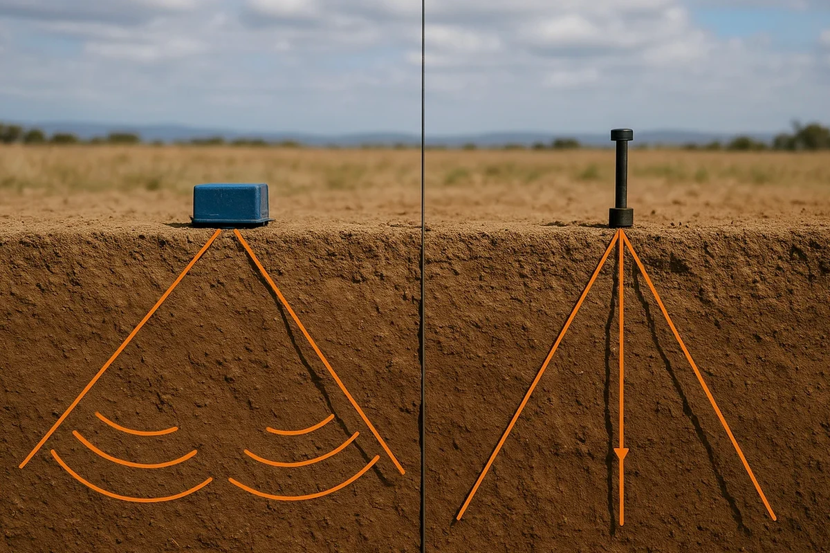
A single seismic line replaces a dozen boreholes for bedrock profiling — continuous, non-invasive, and decisive for foundation depth optimisation.
Methodology applied in Carlow
Local geotechnical conditions in Carlow
Carlow Town and its environs sit at elevations between 45 and 55 metres OD along the River Barrow floodplain, underlain by Dinantian limestones of the Ballyadams Formation. These carbonates have undergone extensive dissolution since the Pleistocene, creating an epikarst surface with solution pipes, grikes, and occasional buried dolines now concealed beneath low-permeability till. A foundation designed for uniform rockhead can encounter differential settlement if a single solution feature goes undetected between boreholes. Seismic tomography mitigates this risk by imaging the till-bedrock contact continuously, flagging velocity inversions below 1500 m/s that correlate with soft infill or voids. The cost of a remediation grouting programme triggered by an unforeseen karst cavity typically exceeds five times the cost of the seismic survey that would have identified it during design stage. On brownfield sites within the town boundary, where historical backfill and buried services complicate electromagnetic methods, seismic reflection provides a mechanically coupled alternative unaffected by cultural noise.
Our services
Seismic field programmes in Carlow are designed around the specific geological target: bedrock profiling, rippability assessment, or stratigraphic mapping of overburden. Each survey includes acquisition design, field deployment, processing with tomographic inversion, and georeferenced deliverables.
Seismic Refraction Tomography
First-break picking and damped least-squares inversion for 2D P-wave velocity models. Applied to bedrock profiling, rippability classification, and landfill/depth-to-rock assessment.
High-Resolution Seismic Reflection
CDP profiling with 1–2 m station spacing for detailed imaging of shallow stratigraphy, buried channels, and karst features. Best suited for sites where refraction is limited by velocity inversions.
MASW (Surface Wave Analysis)
Active-source surface wave acquisition for Vs profiles to 30 m depth. Classifies site per EN 1998-1:2004 for seismic design category; relevant for multi-storey structures in Carlow.
Downhole and Crosshole Seismic
Borehole-deployed source and receiver arrays for interval velocity measurements. Calibrates refraction models and provides direct dynamic moduli (Gmax, Ed) for foundation analysis.
Questions and answers
Can seismic tomography detect solution cavities in the limestone beneath Carlow?
Seismic refraction tomography identifies cavities indirectly through velocity reduction: an air- or clay-filled void will show P-wave velocities below 1200 m/s, contrasted against intact limestone at 3500–4500 m/s. The lateral resolution depends on geophone spacing; with 5-metre spacing, features larger than approximately 3 metres across are reliably imaged. For higher-resolution cavity detection, high-frequency reflection profiling or crosshole tomography between boreholes provides finer detail.
How much does a seismic refraction or reflection survey cost for a typical site in Carlow?
A seismic survey on a standard commercial or residential site in Carlow typically ranges from €2,360 to €4,190, depending on the array length, target depth, and whether both refraction and reflection processing are required. Larger infrastructure projects with multiple survey lines or complex processing workflows are quoted on a project-specific basis after reviewing site plans and geological objectives.
How long does field acquisition take and does it disrupt ongoing construction?
A single seismic line of 115 metres with 24 channels typically requires two to three hours of field time, including array layout, source impacts, and quality control checks. The operation is entirely surface-based and non-invasive; no excavation, drilling, or heavy traffic is generated. Construction activities within 50 metres of the active spread should be paused during shot records to minimise vibration noise, but the interruption is brief and can be scheduled around site operations.
Is seismic reflection effective in the glacial till overburden found across County Carlow?
Yes, the dense lodgement tills of the Carlow area form a strong acoustic impedance boundary with the underlying limestone, producing clear and mappable reflections. The main limitation is signal attenuation in unsaturated, gravel-rich tills; in these cases, a weight-drop source with sufficient energy and careful static corrections during processing ensure reliable imaging of the bedrock reflector.